Tornado damage in Brownsburg, IN. https://www.youtube.com/watch?v=jzG8h4pOSJM

Tornado damage in Brownsburg, IN. https://www.youtube.com/watch?v=jzG8h4pOSJM

#EAS #WEA for Clark, #IN; #Floyd, #IN; #Harrison, #IN: National Weather Service: #TORNADO WARNING in this area until 12:00 AM EDT. Take shelter now in a basement or an interior room on the lowest floor of a sturdy building. If you are outdoors, in a mobile home, or in a vehicle, move to the closest substantial shelter and protect yourself from flying debris. Check media. Source: NWS Louisville KY #Clark, #IN; #Floyd, #IN; #Harrison, #INwx** DO NOT RELY ON THIS FEED FOR LIFE SAFETY, SEEK OUT OFF

That was honestly one of if not the worst storm we’ve had come through here in the 13 years we’ve been in this house. Very wild.
I did a quick walk around the property and I don’t see any damage, but obviously I’ll have to check in the morning light.
The worst of it looks to have gone *just* north of us. We’re probably quite lucky the storm was moving northeast and not just east.
Sheesh.

#NWS #flood #nwsflashflood #FlashFloodWarning Flash Flood Warning for Boone, IN; Hamilton, IN; Hancock, IN; Hendricks, IN; Johnson, IN; Marion, IN; Morgan, IN; Shelby, IN #INwx https://alerts-v2.weather.gov/search?id=urn:oid:2.49.0.1.840.0.fefad9237ede44e955bdd5f35865b7fcaf4c7332.001.1


TDS NW of Muncie, IN now. This is one weird hybrid supercell-QLCS chimera. #INwx

Multiple circulations on this Brownsburg, IN hook echo. Not good. #inwx

Well, *gulp* #inwx

Tornado sirens. Northwest Indianapolis (Eagle Creek) #inwx
Very sharp warm front still moving north, 10C difference between northern and southern Ft. Wayne Indiana and a 20C difference at KFWA since this AM.


That is a crazy amount of tornado warnings.
Red outline - #TornadoWarning
Yellow outline- #SevereThunderstormWarning
Green outline - #FlashFloodWarning
For details from NOAA, open the map, click in an outlined area and follow the link.
To search on a town or address, click/tap Menu > Search.
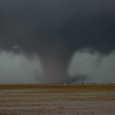
#Tornado #SevereWeather #ARwx #MOwx #ILwx #INwx

PDS Tornado Watch 
URGENT - IMMEDIATE BROADCAST REQUESTED
Tornado Watch Number 98
NWS Storm Prediction Center Norman OK
250 PM CDT Wed Apr 2 2025
The NWS Storm Prediction Center has issued a
* Tornado Watch for portions of
Eastern and South-Central Arkansas
Southern Illinois
Southwest Indiana
Western Kentucky
Southeast Missouri
Northern Mississippi
Western Tennessee
* Effective this Wednesday afternoon from 250 PM until Midnight CDT.
...THIS IS A PARTICULARLY DANGEROUS SITUATION...
* Primary threats include...
Several tornadoes and a few intense tornadoes likely
Widespread damaging winds and isolated significant gusts to 80 mph likely
Scattered large hail and isolated very large hail events to 2 inches in diameter possible

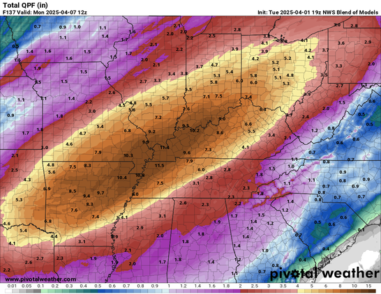
NOAA has been warning for several days about the “historic” weather event starting today. The main feature will be massive amounts of rain over several days. However, other nasty weather, including tornadoes, will also be in the mix.
The screenshot text is from NOAA’s forecast discussion for the area that covers parts of TN, AR and MO. That area is labeled MEG on the map
To read the full forecast discussion for any area, open the map, click/tap inside any of the large red-outlined areas and then follow the link.
#SevereWeather #MOwx #INwx #KYwx #ARwx #TNwx


The yellow area on the map is NOAA’s estimate for where the most rain will fall over the next 5 days. NOAA has posted a flood watch for this area which says in part:
“Historically high forecast rainfall amounts will create a particularly dangerous situation with respect to the risk of flash flooding and flooding Wednesday through Sunday.”
When the map opens the layer with NOAA’s forecast discussion is on top and can be clicked. The text screenshot is a snip from the forecast discussion for part of the area where the most rain is expected.
The map has a lot of weather related #GIS layers that you can turn on/off/restack. The ‘Map tips” link on the upper left corner of the map will show you how.
#SevereWeather #MOwx #INwx #KYwx #ARwx #TNwx


The Eyewall: Potential for catastrophic flooding by the weekend in the Mid-South and near the Ohio Valley
"...The National Weather Service in Paducah, KY did not mince words this afternoon in their briefing on the upcoming rainstorm across the Ohio Valley: “Significant and potentially historic rainfall will begin Wednesday afternoon, with numerous rounds of heavy rain continuing into the first half of the weekend, leading to potentially catastrophic flash flooding.”
..."

Blog post: Hurricane-force thunderstorm winds, tornadoes possible throughout Indiana April 2 #INwx #severeweather

Nasty severe weather line starting to form in Illinois/Indiana/etc.


 Confirmed: Network data show a decline in internet connectivity across