One of the construction workers on the tower going up right by me lost her hard hat to the wind. I watched it blow off. Hope nobody on the sidewalk was hit by it, she’s on the 17th floor. #YVR #BCstorm
Recent searches
Search options
#yvr
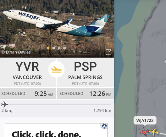
Watching the air traffic at #YVR #Vancouver. Mexico, Mexico, Mexico, lol.
Wonder if this flight to Palm Springs is full?
#TradeWar #SpringBreak #Canada #TrumpTariffs
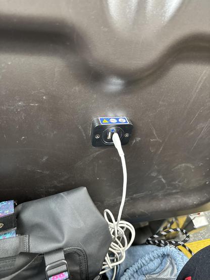
My wife and son are off on a grand trip... and I am jealous, not for the beach they're going to (ok, a little) but for the -- apparently -- brand new transit bus they're riding right now from the Tsawwassen Ferry to Bridgeport station near #YVR! (#620)
We usually travel to Horseshoe Bay terminal and take transit (often articulated #255) in to downtown Vancouver from there.
Charging ports and Reading lights on a double decker bus!!?? WHAAT!
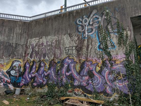
A place to put your pain, your consequence
When you look into the mirror
Are you even there?"
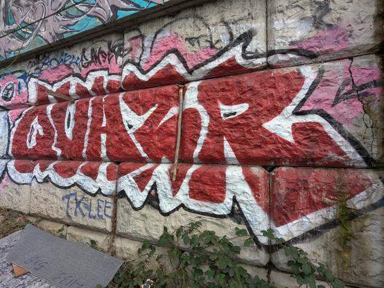
#badomens #likeavillain #art #urbanart #streetart #graffiti #tagging #throwies #bombs #dtes #yvr #vancity #vancouver #eastvan #quazr #tklee #sapa #sober #fumar #homeless #love #stayqueer #youareloved
White Rock #sunrise.
New article: Monday earthquake shakes Vancouver, Seattle - are earthquakes striking more than usual?
A review of this morning's #earthquake as well as a look at data to see how the last few months compare to long-term data.
Seismograph display from #Vancouver of the M4.8 #earthquake that struck at 13:26 PT Friday.
This Thursday Feb 20 at 6:30 pm we are cohosting our first IRL meetup of the year:
Come meet #CoSocialCa members and friends in Vancouver and grab one of our slick new stickers
Are you interested in hosting an event in your city next? Let's chat about how to do that!
#Vancouver #weather
20250213
Increasing clouds today and tomorrow, high today around 4, high tomorrow around 6. Warming to closer to 8 by Sunday. Rain showers begin tomorrow night. Some snow may mix in early Sat and on hilltops during the day.
Possible high-end snow event for parts of Metro Vancouver Sunday-Monday
The Pacific storm train is once again aimed at British Columbia with light rain falling in Metro Vancouver early Friday morning. Rain tapers off this afternoon but we will likely see some showers on Saturday.
Cold air diving south from Yukon into the B.C. Interior through this weekend will drop temperatures enough in the Lower Mainland to talk about snowfall beginning Sunday afternoon and lasting into Monday.
Ingalls Weather thanks the support it gets from donors. Please consider making a small donation at this link [ingallswx.com] to help me pay for the website and access to premium weather data.
A note before we get into specifics: This is a highly dynamic forecast. Small shifts in the position of certain weather features will create large shifts in observed snowfall. Additionally, this may be a situation where parts of the metro only get a few centimetres of snow while others exceed 20 cm (8 inches) just a few kilometres away.
My goal is to provide enough context here to give readers a good grasp on the dynamics and possibilities. This is one of those low confidence but high impact forecasts. In reality, we probably won’t know who will get what until the event starts.
Low pressure is forecast to slide down the British Columbia coast before parking off the Olympic Peninsula on Monday. This low will generate convective snow showers and some of them will be strong. Since the snow will be showery in nature instead of covering a large area at once (like in a cold front) conditions will vary greatly from place to place.
[Adding to this, low level winds may create a convergence zone over Metro Vancouver. When this happens, wind moving in different directions crashes into each other, is forced upward, and enhances cloud formation to generate heavy precipitation.
The Seattle-area is famous among meteorologists for their convergence zone. When winds are out of the west they split to go around the Olympic Mountains and come back together usually between Seattle and Everett to form a narrow corridor of heavy rain or (if it’s cold enough) heavy snow.
Sunday into Monday, low level winds will be traveling from south(ish) to north(ish) across Western Washington. They will have to go around the Olympic Mountains and come back together somewhere near Metro Vancouver. It looks like additional lift will be provided from offshore winds coming down from the Fraser Plateau.
It looks like right now there is a 65% chance this convergence zone sets up. The question becomes who will be under it? The ECMWF puts the band of heavy snow along a line from near White Rock to near Maple Ridge. Meanwhile, The Weather Channel’s GRAF model runs it from Point Roberts across Richmond and Vancouver to Grouse Mountain.
Under every scenario I’ve seen so far, Abbotsford and Bellingham are largely left out of the party. Snow showers are likely there but the convergence zone looks like a Metro Vancouver affair. Point Roberts, Blaine, and Ferndale may also come under the convergence zone.
Because convergence zones bring heavy precipitation and park over one area for several hours at a time, snow totals under it may fall in the 10 to 20 cm (4 to 8 in) range. Isolated totals in excess of 30 cm (12 in) are possible. Outside the convergence zone look for snowfall totals generally around 5 to 10 cm (2 to 4 in).
The mountains are likely to get loaded with snow this weekend. It was already cold enough for snow down to Simon Fraser University on Thursday. Low snow levels and convective precipitation are excellent for strong snowfall. As of 08:00 Friday Mount Seymour was reporting 36 cm (14 in) of new snow in the last 24 hours.
Other convergence zones appear possible in the region, both to the south in Washington and further north up the Strait of Georgia. Heavy mountain snow will make travel difficult.
Use caution when looking at individual weather models and computer-generated forecasts like those on mobile apps. These show possible solutions but in this weather regime they fail to provide the necessary context.
Any forecast (human or computer) that provides a single value for total snowfall will be wrong and may be wildly off. For Sunday and Monday, it is best to be prepared for significant snowfall while understanding that not everyone in Metro Vancouver will see it.
There is a small chance that all this will manifest itself as cold rain. I don’t see that as being very likely because strong showers lower the snow level through a process called evaporative cooling. Even under warmer solutions, temperatures are cold enough for evaporative cooling drop snow down to sea level.
The cold air inland will also produce a modest Fraser Outflow wind event beginning Sunday and lasting through at least Tuesday. Gusty winds will be observed from Abbotsford to Victoria, including parts of Whatcom County and the San Juan Islands. The outflow air is dry and will probably limit snowfall totals along this corridor to some extent.
It looks like cold air will be settled into British Columbia for some time. Lows in the Lower Mainland away from water will probably approach -10°C (14°F) during the second half of the week. Up in Prince George lows will likely get below -25°C (-13°F).
Over the next 36-hours we will get more data from weather models that have higher resolution. These won’t be perfect either, but they capture the terrain better and will give additional perspectives. I’ll be sharing Metro Vancouver updates on Mastodon [mstdn.ca], BlueSky [bsky.app], and Facebook [www.facebook.com]. The Vancouver & the Lower Mainland Weather Page [www.facebook.com] on Facebook is another useful place to go.
Other Pacific Northwest cities could see some snow in the coming week as well but it’s too far out to give specifics. Portland and the Tri-Cities (WA) may be looking at a midweek scenario. More details on that as we get closer.
It's been a while since i have seen our local beavers.
Just a juvenile and its mother. Nikon Z5 200-500mm #wildlifePhotography #naturePhotography #beaver #Vancouver #photography #Nikon #yvr
Thought related to this story about the demise of AM730 radio station.
I wonder if there is a way where a hashtag like #YVRDrives could exist so that the feed was announced audibly.
Every new post in the feed announced in someone's notifications? Could it work as a replacement or augmentation to traffic radio stations or would it just be too chaotic?
Welcome to new #SocialBC member @HUBnorthshore!
Check them out for Cycling related content on the North Shore #Vancouver #YVR including North and West Van, #BowenIsland and #LionsBay!
Good 2025 morning to everyone!
Please give our new friends on #socialBC a follow!
Extra big welcome to @JordSharpeBC who just joined this morning!
@alberniweather
@SookeSailingCoop
@Dero
@cageyratfish
@artbysarahsammis
@vibyrail
@bcwidebus
@PhotographyElf
@arbutus
@jrenken
Welcome to 2025 BC!! SocialBC.ca is officially open to all residents and those connected to British Columbia!
Cheers to 2025! We’re going to make this the Year of the #Fediverse!
Let’s grow the #OpenSocialWeb right here in our communities.
Create an Account: https://socialbc.ca
And if you’d like to support financially: https://www.paypal.com/donate?campaign_id=NYQ8LSFB5GP6N
Possibly a coal conveyor caught fire at Westshore terminals coal port in Vancouver (Deltaport) near the Ferry Terminal.
https://vancouver.citynews.ca/2024/12/28/delta-tsawwassen-fire-black-smoke-near-deltaport/
Thanks @martin_fff
#bcpoli #coal #shipping #fire #bcemergency #yvr #bcferries


