
Rainfall continues. #flooding #FlashFlooding #SevereWx

Rainfall continues. #flooding #FlashFlooding #SevereWx

"Potentially catastrophic flooding could occur in the mid-South and Ohio Valley regions as multiple bouts of #ExtremeRainfall impact those regions into the weekend.
Rainfall totals could reach 10 inches or more in what some National Weather Service offices are calling a "particularly dangerous situation" that will produce life-threatening #FlashFlooding as well as major flooding that could approach record levels in some locations. "
"#ClimateChange is bringing heavier rainfall extremes and increased, inequitable flood risk to many parts of the U.S.
For every 1°F of warming, the air can hold 4% more moisture, increasing the chances of heavier downpours that contribute to #FlashFlooding hazards. "
https://www.climatecentral.org/climate-matters/heavier-rainfall-rates-in-us-cities
#ExtremeRain

Major extreme weather event incoming for the US.
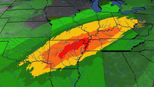
Excessive Rainfall Discussion
NWS Weather Prediction Center College Park MD
339 AM EDT Wed Apr 2 2025
Day 1
Valid 12Z Wed Apr 02 2025 - 12Z Thu Apr 03 2025
...THERE IS A MODERATE RISK OF EXCESSIVE RAINFALL FROM SOUTHERN ARKANSAS TO SOUTHERN INDIANA...
..A PROLONGED LIFE-THREATENING FLASH FLOOD EVENT WILL BEGIN TODAY
WITH SEVERAL DAYS OF HEAVY RAINFALL IMPACTING A LARGE PORTION OF THE LOWER MISSISSIPPI AND OHIO VALLEY'S..
(continued)
https://www.wpc.ncep.noaa.gov/qpf/ero.php?opt=curr&day=1
NWS:
"Significant and potentially historic rainfall will begin Wednesday afternoon, with numerous rounds of heavy rain continuing into the first half of the weekend, leading to potentially catastrophic flash flooding"

Risk rises for #mudslides around #LACounty fire zones; prepare for worst-case scenario, officials warn
Alene Tchekmedyian, Rong-Gong Lin II, Melody Gutierrez, LA Times
January 26, 2025
"With more rain on the way, officials warned Sunday of an increasing risk of mudslides in #LosAngelesCounty's burn areas, with a 10% to 20% chance of significant #FlashFlooding and #DebrisFlows capable of damaging roads and homes in and around areas devastated by #wildfires.
"'This is the worst-case scenario to prepare for,' said Kristan Lund, a meteorologist with the National Weather Service in Oxnard.
"'We do have increasing concern for the #BurnScars,' Lund said. The charred footprint of the Eaton fire, which blackened more than 14,000 acres, is the most worrisome. 'These #FlashFloods and these debris flows could happen in and near or below these burn scars.'
"A #FloodWatch took effect at 10 a.m. Sunday and was set to continue through 4 p.m. Monday for the burned areas of the #EatonFire in the #Altadena and #Pasadena areas; the #PalisadesFire and #FranklinFires in the Pacific Palisades and Malibu areas; the Hughes fire around Lake Castaic; and the Bridge fire in the San Gabriel Mountains west and southwest of Wrightwood. The flood watch started six hours earlier than originally anticipated as rain began falling steadily around Los Angeles."
Read more:
https://www.aol.com/news/risk-rises-mudslides-around-l-170323295.html
#ClimateCrisis #CaliforniaFires #BurnScar #FlashFloodWarning #FloodDanger #Mudslides #CaliforniaWx
Tropical Depression 10E:
"Slow-moving Tropical Depression Ten-E will bring very #HeavyRainfall to coastal portions of southern and southwestern #Mexico through the upcoming week. This heavy rainfall will bring a risk of significant #FlashFlooding and mudslides to the Mexican States of #Chiapas and #Oaxaca, particularly in areas near the coast.
"The depression is forecast to become a tropical storm while moving near the coast of southern Mexico on Monday or Tuesday. A Tropical Storm Watch has been issued for a portion of the coastline, where tropical storm conditions could begin on Tuesday.
"The system could strengthen more than forecast if it remains over water. Interests along the coast of southern Mexico should monitor the latest forecast updates, as a Hurricane Watch could be required for a portion of the coastline later tonight or on Monday.
"Convection has gradually become better organized today (22 September) in association with an area of low pressure that the NHC has been monitoring off the coast of southern Mexico. A recent scatterometer pass shows the circulation is closed, with a well-defined center and peak winds of about 35 mph (30 knots) over the southern semicircle. Therefore, a new tropical depression has formed in the eastern Pacific basin.
"The depression is nearly stationary, but a slow northeastward drift is expected to begin later tonight. The track forecast is challenging, as there is a large spread in the guidance regarding the potential path of the system. Much of the track guidance shows the system moving generally east-northeastward as it becomes captured within the broader circulation of a developing Central American Gyre. However, a couple of global models (ECMWF and UKMET) instead show a northward drift over the next couple of days. The NHC track forecast favors the first scenario, and generally lies between the simple and corrected consensus aids. However, this track forecast is of low confidence given the large spread in the models, and adjustments will likely be required with future issuances.
"The moist, unstable environment and very warm waters should be conducive for some strengthening of the system during the next couple of days. The NHC intensity forecast lies between the IVCN and HCCA aids, but it should be noted that there are some models indicating the system could reach hurricane strength. While this is not explicitly forecast, it certainly cannot be ruled out given the environmental and oceanic conditions, and interests along the coast of southern Mexico should monitor the latest forecast updates. The peak intensity of the system will be highly dependent on how long the cyclone remains over water before reaching the coast, which is quite uncertain given the track challenges described above.
"Based on this forecast, the government of Mexico has issued a #TropicalStormWatch for the southern coast of Mexico from Punta Maldonado to Salina Cruz."
Forecaster Reinhart. Advisory Number 1. Information provided by the National Hurricane Center (NHC).
https://zoom.earth/storms/10e-2024/#map=precipitation/model=icon
AZ: "Arizona National Guard rescues over 100 people after Havasupai reservation flooding" 8/24/24 https://www.azcentral.com/story/news/local/arizona/2024/08/24/arizona-national-guards-havasupai-reservation-flood-rescue-underway/74935185007/ #AZwx #SearchAndRescue #SAR #FlashFlooding #GrandCanyonNationalPark
Hmm, anyone check on W1AW today? #CTwx #flashflooding #hamradio #W1AW
CNN: Flash flooding emergency in Connecticut prompts water rescues, evacuations https://www.cnn.com/2024/08/18/us/connecticut-flooding-rescues/index.html #CTwx #FlashFlooding
Pity the fool in a slot canyon in monsoon season in a hypercharged rainfall season. "Prepare Accordingly".... (per UT Emery County Sheriff's Office). Notably, they are unlikely to get this warning (WEA, transmitted over cell phone towers... if you're down in a slot canyon, you're never getting a warning). #flashflooding #slotcanyon #sanrafaelswell #flooding
CNN: Debby-triggered flood emergencies force rescues and evacuations on New York-Pennsylvania border https://www.cnn.com/2024/08/09/weather/tropical-depression-debby-forecast-friday/index.html
#TropicalDepressionDebby #Debby #FlashFlooding #NYwx #PAwx
"Policymakers can often be overly focused on whether their part of the world is becoming wetter or drier overall. But as this new research shows, it’s variability they should be worried about.
Our findings have major implications for [cities'] preparedness for #FlashFlooding. More intense downpours are likely to overwhelm stormwater systems designed for past conditions."
Mojave Desert/Inland Empire/Riverside County/San Bernardino County. No, that's not a giant colon coming, it's an area of slow moving rain cells, i.e. monsoon flash flooding. #CAwx #flooding #FlashFlooding
Radar for that flash flooding over the #Blue2Fire burn scar. #NMwx #wildfires #flashflooding

The end of the road trip?
The culture of 'the drive' requires sisyphean road maintenance, especially in a climate emergency.
Mobile sprawl as a form of 'recreation' eliminates the landscape. It is the annihilation of space and time. Motorists want to get from their door to the spectacle in the fastest way possible. The 'in-between space' viewed through the car window vanishes.
The pleasure cruise from A to B does not just degrade the landscape, but also eradicates possibilities of a livable planet. The overuse by the masses in their fossil fuel boxes makes the hillsides crumble, leads to landslides and erosion. After flash flooding, drought and heatwaves the roads have to be rebuilt over and over again.
Here are three cases of 'scenic drives':
California, Victoria and NSW
Extreme weather is changing California. These road trips show how
https://www.theguardian.com/us-news/2023/dec/28/climate-extremes-california-road-trip
Climate Risk : The Path Ahead for the Great Ocean Road
Unsustainable Tourism
https://www.earlywarningnetwork.com.au/news/the-path-ahead-for-the-great-ocean-road
Waterfall Way scenic drive, NSW
https://www.nationalparks.nsw.gov.au/things-to-do/driving-routes/waterfall-way-scenic-drive
Why is the road called Waterfall Way ?
https://www.abc.net.au/news/2020-12-15/waterfall-way-in-dorrigo-coffs-harbour-wet-weather-nsw/12986532
