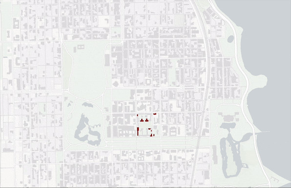
RELEASE: Greater Northshore and MEGAMAP Bike Maps version 1.5.1 - 8 March 2025
Additions and changes this release:
* WATERFRONT TRAIL now open in Downtown Seattle. This is a small section opening, but it is an important connection
* HONEY DEW CREEK TRAIL in Newcastle/Renton. Turns out it's a popular paved shortcut
* Better road name markings a few places
* Warnings on 15th Avenue S bike lanes which are now _closed_ now 'til spring
https://github.com/solarbirdy/NorthshoreBikeMap/
Previous permalinks continue to work.
If you like these maps, maybe hit my Patreon:
https://www.patreon.com/solarbird
Thanks!
GitHubGitHub - solarbirdy/NorthshoreBikeMap: A bike infrastructure mapping project for NW King and SW Snohomish counties, The Greater Northshore Bike Map links the Seattle and 2 Line Eastside maps, making them all more useful. Printed, it folds as small as 4x7". The MEGAMAP edition combines those maps plus Greater Newcastle into a large foldable poster for display or backpack use.A bike infrastructure mapping project for NW King and SW Snohomish counties, The Greater Northshore Bike Map links the Seattle and 2 Line Eastside maps, making them all more useful. Printed, it fol...


 How can you transform a sequence of points into complete routes that follow roads, sidewalks, or tracks?
 It's easy with our Map Matching endpoint. Example code in TypeScript, Python, Kotlin, Swift, and PHP.


 showing a bird's eye view of a rural landscape with lots of forest that forms the head of a wolf (the ears are mountains, the eyes and nose are lakes etc). It's night with a moon, no cars but public transport (train and bus). Around it is written: „Return the wolf, let nature heal.“")
 Are you using Leaflet, but you want to incorporate our vector styles?
 Learn how with the help of MapLibre GL JS and our tutorial.